Lessico
Cristoforo Buondelmonti
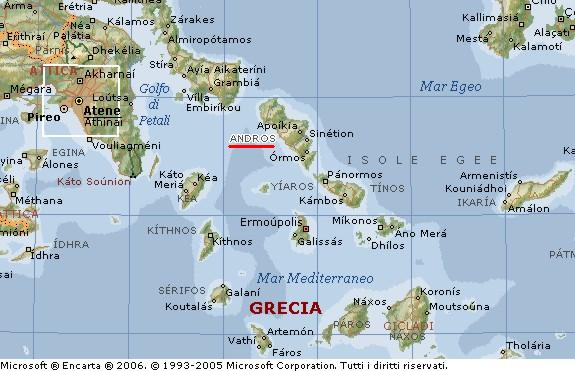
L'isola
di Andros dove Cristoforo Buondelmonti nel 1419 scoprì il manoscritto dei Hieroglyphiká di Orapollo![]() - Andros
(anche Andro, in greco Ándros) è un'isola della Grecia sudorientale situata
nel Mar Egeo. È la più settentrionale delle Cicladi e ha una superficie di
381 km². È prevalentemente montuosa e ha coste frastagliate. I prodotti
principali sono vino e agrumi. Il più importante centro abitato è Andros,
sulla costa orientale; la popolazione è di circa 9000 abitanti. Abitata
anticamente dagli Ioni, prese il nome da Andreo suo mitico colonizzatore. Si
rese indipendente da Atene intorno al 411 aC, dopo essere stata costretta ad
accettarne il dominio. Divenne parte del regno ellenistico di Pergamo (in Asia
Minore) nel 200 aC e fu annessa a Roma nel 133 aC. Nel 1207 passò sotto il
controllo dei Veneziani, che lo mantennero fino al 1566, anno in cui fu
conquistata dai Turchi. Ritornò a far parte della Grecia nel 1829.
- Andros
(anche Andro, in greco Ándros) è un'isola della Grecia sudorientale situata
nel Mar Egeo. È la più settentrionale delle Cicladi e ha una superficie di
381 km². È prevalentemente montuosa e ha coste frastagliate. I prodotti
principali sono vino e agrumi. Il più importante centro abitato è Andros,
sulla costa orientale; la popolazione è di circa 9000 abitanti. Abitata
anticamente dagli Ioni, prese il nome da Andreo suo mitico colonizzatore. Si
rese indipendente da Atene intorno al 411 aC, dopo essere stata costretta ad
accettarne il dominio. Divenne parte del regno ellenistico di Pergamo (in Asia
Minore) nel 200 aC e fu annessa a Roma nel 133 aC. Nel 1207 passò sotto il
controllo dei Veneziani, che lo mantennero fino al 1566, anno in cui fu
conquistata dai Turchi. Ritornò a far parte della Grecia nel 1829.
![]()
![]()
![]()
Cristoforo Buondelmonti, monaco, nato nel 1386 da una potente famiglia fiorentina originaria della Val di Greve (dove, almeno dal sec. XIII, possedeva il castello di Montebuoni e terre in Valdipesa, estintasi nel sec. XVIII), che aveva forti legami con il Levante, si formò con ogni probabilità alla scuola di Guarino Veronese (Verona 1374-Ferrara 1460) ed era legato alla cerchia umanistica di Niccolò Niccoli (Firenze ca. 1364-1437) appassionato ricercatore di testi classici,, con il quale condivise l'interesse per la geografia.
Lasciata Firenze, nel 1414 si recò a Rodi, per riscoprire le tracce dell'antica civiltà greca e per oltre sedici anni percorse tutte le isole, le città, i monasteri del mare Egeo, Creta, Cipro, l'Ellesponto, Costantinopoli. Frutto di queste lunghe peregrinazioni nella culla della civiltà greca sono due opere storico-geografiche, la Descriptio insulae Cretae, inviata nel 1417 a Firenze a Niccolò Niccoli e il Liber insularum Archipelagi, dedicato a al cardinale Giordano Orsini nel 1420.
Il Liber insularum conobbe quattro rielaborazioni, quella definitiva redatta a Costantinopoli nel 1430 (la prima è perduta). L'opera ebbe da subito una grande fortuna - sopravvive infatti in numerosi esemplari manoscritti sia nelle biblioteche italiane che europee; venne inoltre ripresa negli isolari manoscritti e a stampa di fine Quattrocento e del Cinquecento, quali gli Isolari illustrati di Henricus Martellus, di Bartolomeo de li Sonetti e di Giovanni Bordone - fonda il genere degli isolari, uno dei più significativi linguaggi rinascimentali di rappresentazione dello spazio; un linguaggio che combinava e fondeva le forme simboliche della cartografia nautica, della corografia storico-descrittiva con il linguaggio storico-letterario proprio degli itinerari.
Il testo greco dei Hieroglyphiká di Orapollo![]() fu scoperto nel 1419 da Cristoforo
Buondelmonti nell’isola greca di Andros nel Mar Egeo, la più settentrionale
delle Cicladi, nella cui provincia è inclusa. L’arrivo a Firenze, nel 1422,
del manoscritto dei Hieroglyphiká, acquistato da Buondelmonti per
conto di Cosimo de' Medici, suscitò scalpore, poiché finalmente si aveva
un’opera che, si riteneva, sarebbe stata in grado di spiegare il senso
occulto dei misteriosi geroglifici egizi. Il testo presentava numerose lacune,
ma, nonostante questo, conobbe un’ampia diffusione e fu oggetto di
appassionate discussioni, tanto da essere, per tutto il Rinascimento,
all’origine delle idee che si avevano sui geroglifici. Cristoforo morì
intorno al 1430.
fu scoperto nel 1419 da Cristoforo
Buondelmonti nell’isola greca di Andros nel Mar Egeo, la più settentrionale
delle Cicladi, nella cui provincia è inclusa. L’arrivo a Firenze, nel 1422,
del manoscritto dei Hieroglyphiká, acquistato da Buondelmonti per
conto di Cosimo de' Medici, suscitò scalpore, poiché finalmente si aveva
un’opera che, si riteneva, sarebbe stata in grado di spiegare il senso
occulto dei misteriosi geroglifici egizi. Il testo presentava numerose lacune,
ma, nonostante questo, conobbe un’ampia diffusione e fu oggetto di
appassionate discussioni, tanto da essere, per tutto il Rinascimento,
all’origine delle idee che si avevano sui geroglifici. Cristoforo morì
intorno al 1430.
Cristoforo Buondelmonti was born in Florence (Firenze), Italy in about 1385. He is a famous Italian traveler of the fifteenth century and a pioneer in promoting first-hand knowledge of Greece and its antiquities throughout the Western world. He left Florence around 1414 in order to travel, mainly in the Greek islands. He visited Constantinople in the 1420's. He is the author of two historical-geographic works: the Descriptio insulae Cretae (1417) and the Liber insularum Archipelagi (1420). These two books are a combination of geographical information and contemporary charts and sailing directions. He died c. 1430.
Cristoforo Buondelmonti (Florence ~1380 - ~1430) est un religieux florentin et un voyageur. Né dans une famille aristocratique de Florence, il quitta la ville vers 1414 ou 1415 pour Rhodes. Il séjourna huit ans en Grèce, peut-être au service des Ducs de Naxos ou des établissements religieux catholiques de l'Égée. Il en profita pour apprendre le grec. Il parcourut encore les îles, Cyclades et Îles Ioniennes, pendant six ans. Très influencé par la Géographie. de Ptolémée. Il décrivit et dessina les îles grecques. Comme tous les érudits il se livra à la chasse aux manuscrits anciens, mais chose plus rare, il s'intéressa aux antiquités qu'il décrivit de visu et à partir de ses sources antiques. Il fit un travail important sur l'île de Délos, littéraire, avec une description de l'île, mais il essaya aussi de ré-ériger une statue archaïque d'un Apollon.
Œuvres - Descriptio Insulae Cretae (Description de l'île de Crète) 1417 - Liber Insularum Archipelagi (Livre des Îles de l'Archipel c'est-à-dire de l'Égée) 1420, dédié au cardinal Giordano Orsini. - Nomina Virorum Illustrium (Vie des Hommes illustres) commandé par Janus, roi de Chypre.
Andros, or Andro (Greek: Ἄνδρος), an island of the Greek archipelago, the most northerly of the Cyclades, approximately 10 km (6 miles) south east of Euboea, and about 3 km (2 mi) north of Tinos. It is nearly 40 km (25 mi) long, and its greatest breadth is 16 km (10 mi). Its surface is for the most part mountainous, with many fruitful and well-watered valleys. Andros, the capital, on the east coast, contained about 2000 inhabitants in 1900. The island had about 18,000 inhabitants in (1900). The 1991 census reads 8,781. According to the latest Greek census of 2001, the town of Andros still contained 1,508 inhabitants, and the island's total was 10,009. The island is comprised of the municipalities of Andros (pop. 4,107), Korthion (pop. 2,547), and Ydrousa (pop. 3,355). Their combined land area is 380.041 km². The largest towns are Ándros, Gávrio, Bátsi, and Órmos Korthíou.
History
The island in ancient times contained an Ionian population. Though originally dependent on Eretria, by the 7th century BC it had become sufficiently prosperous to send out several colonies, to Chalcidice (Acanthus, Stageira, Argilus, Sane). The ruins of Palaeopolis, the ancient capital, are on the west coast; the town possessed a famous temple, dedicated to Dionysus. In 480 BC it supplied ships to Xerxes and was subsequently harried by the Greek fleet. Though enrolled in the Delian League it remained disaffected towards Athens, and in 477 had to be coerced by the establishment of a cleruchy on the island; nevertheless, in 411 Andros proclaimed its freedom, and in 408 withstood an Athenian attack. As a member of the second Delian League it was again controlled by a garrison and an archon.
In the Hellenistic period Andros was contended for as a frontier-post by the two naval powers of the Aegean Sea, Macedon and Ptolemaic Egypt. In 333 it received a Macedonian garrison from Antipater; in 308 it was freed by Ptolemy I of Egypt. In the Chremonidean War (266-263) it passed again to Macedon after a battle fought off its shores. In 200 it was captured by a combined Roman, Pergamene and Rhodian fleet, and remained a possession of Pergamum until the dissolution of that kingdom in 133 BC. Before falling under Turkish rule, Andros was from A.D. 1207 till 1566 governed by the families Zeno and Sommariva under Venetian protection. After a few centuries, Cyclades joined the rest of Greece in 1821.
On May 10, 1821, Theophilos Kairis, one of the leading intellectuals of the Greek Revolution, declared the War of Independence by raising the Greek flag at the picturesque cliffside church of St George: at this time, a famous heartfelt speech, or "rhetoras", inspired shipowners and merchants to contribute funds to build a Greek Navy to combat the Ottomans.
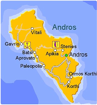
Andros City
Andros (Chora or Hora, pop. 1,508), the capital of the island, is on a headland between two beaches. It has a mix of post-World War I neoclassical mansions with vernacular Cycladic houses. The town squares are paved with marble. At the end of the headland are two islands, the first linked to the mainland by a brick bridge a ruined Venetian castle and the second a lighthouse. There are four museums: the extensive Archaeological Museum, Museum of Modern Art, a Nautical Museum and a Folklore Museum. The island is famous for its Sariza spring at Apoikia where the water comes out of a lionhead.
The north of Andros has a small Arvanite community, and an Arbëresh village in Sicily called Piana degli Albanesi is named 'Hora' in Arbëresh, possibly after the capital of Andros, also called Hora. Palaeopolis, the ancient capital, built into a steep hillside, and its harbor's breakwater can still be seen underwater.
![]()